The 2024 Virginia Uniform Statewide Building Code, which adopts the IBC, leaves no room for guesswork. Section 1803 explicitly requires soil classification for foundation design. Richmond adds its own layer of complexity. The city straddles the Fall Line, meaning a site in Shockoe Bottom might reveal deep alluvial silts while a site just three miles west in the Fan District hits residual Piedmont clays. An exploratory test pit delivers the visual evidence engineers need. It exposes stratigraphy directly. No lab abstraction. For preliminary assessments, we often pair this with an Atterberg limits analysis right from the exposed face to verify plasticity. The goal is always the same: give the structural engineer a defensible bearing capacity before the first yard of concrete arrives.
In Richmond's Fall Zone geology, a 10-foot test pit reveals more about bearing capacity than 50 feet of speculation.
Technical details of the service in Richmond Virginia
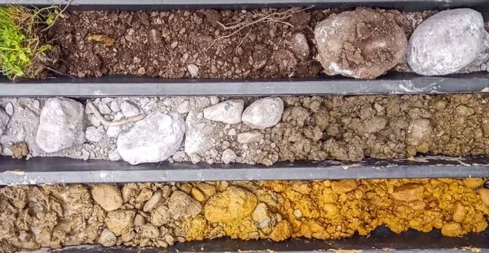
Field demonstration
Critical ground factors in Richmond Virginia
Richmond sits at an elevation range that drops from roughly 190 feet in the West End to near sea level at the James River docks. That gradient hides old stream channels and undocumented fill. We excavated a pit off Broad Street where the top six feet looked like natural clay, but the bottom four feet were saturated cinders from a 19th-century rail spur. The structural load was supposed to transfer at five feet. That discovery moved the footing elevation. Ignoring a test pit here means betting the foundation on whatever lies beneath the surface. When the river floods, as it does regularly past the 9-foot flood stage, loose fill layers can settle differentially. The exploratory test pit is your first line of defense against those hidden compressible lenses.
Our services
Our Richmond test pit programs deliver more than a hole in the ground. Each investigation produces actionable data for foundation design.
Visual Stratigraphic Logging
Detailed face mapping by a field engineer. Every change in color, density, and moisture is documented and photographed before the pit collapses.
In-Situ Density Sampling
Bulk samples taken directly from the pit wall at target elevations. These feed lab programs for classification and compaction control.
Fill Material Verification
Rapid identification of debris, organics, or buried structures in areas of known historical disturbance across the Shockoe and Manchester districts.
Groundwater Level Recording
Observation of seepage zones and static water level, critical for basement design in Richmond's low-lying alluvial corridors.
Common questions
What does an exploratory test pit cost in Richmond?
For a standard pit reaching depths between 8 and 14 feet, including a field report with soil classification, the cost typically ranges from US$440 to US$920. The final figure depends on access constraints, the need for traffic control in urban blocks, and the volume of lab testing requested on the recovered samples.
When does the IBC require a test pit instead of just a boring?
The IBC does not mandate test pits over borings universally, but Section 1803 requires adequate soil data. Test pits excel when you need to visually inspect shallow fill, verify rock refusal depth, or sample large volumes of gravelly soil that augers disturb. They are ideal for footing subgrade inspections in Richmond's shallow residual soils.
How do you handle shoring in deep Richmond pits?
We follow OSHA Subpart P strictly. Pits deeper than 5 feet require a protective system unless excavated in stable rock. In Richmond's sandy alluvial soils, we typically use a trench box or slope the walls back at a 1.5:1 ratio. The excavation is classified before entry by a competent person.
Can a test pit detect contamination or environmental hazards?
Our test pits are geotechnical, not environmental. However, visual and olfactory evidence of contamination (staining, odors, buried drums) is immediately flagged. If Phase I ESA data suggests concerns, a separate environmental assessment should run parallel to the geotechnical investigation.
How fast can you mobilize for a test pit in the Richmond area?
Typical mobilization takes 24 to 48 hours after utility marking is complete. Miss Utility clearance is mandatory before any excavation. Once on site, a single pit excavation and logging is usually completed in under two hours, weather permitting.